
Els Slots
Core Zone Maps Update
It was less than 2 months ago that I wrote about the first set of findings from adding core zones to our maps. Within 3 months of having started our mapping project, we’re now past halfway, and we have gone beyond UNESCO's estimation of “48% that have no adequate map“.
Progress
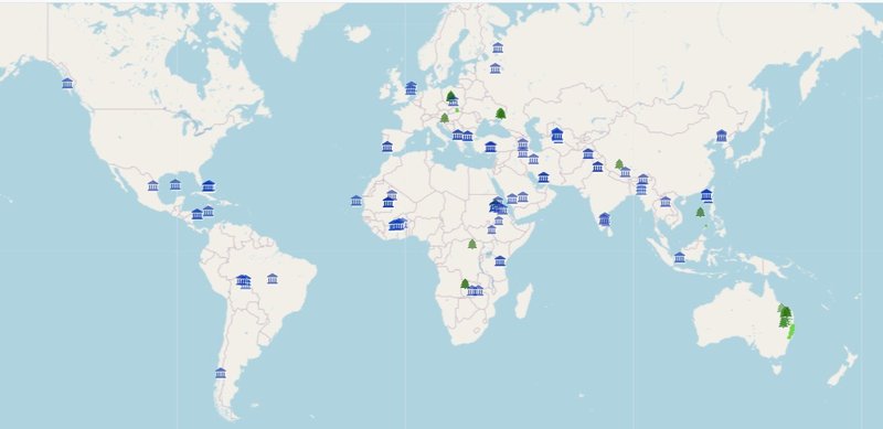
So far, 649 different WHS have been given a Core Zone map and 43 countries are covered in full. To my knowledge, this is already by far the best coverage anywhere on the web; the UNESCO World Heritage Centre added "site boundary polygons" to 289 WHS on the official website, according to its latest report (July 2025).
Community members who submit are considerably more skilled than I expected (or have more stamina than I do), and there are also fewer poor maps than I had been led to believe by UNESCO reports. A core zone border hand-drawn on a physical map may look unprofessional, but that does not mean it is bad per se: as long as the outline follows recognizable elements, you can make sense of it.
The mapped WHS were mostly (547, 84%) drawn by community members. Thank you so much _oscar, mmarquez, JayT, JakobF, Ian, FrédéricM, Digits, Catoplayer, Astraftis, for your contributions. How many core zones you have added to the site shows on your profile page in the About section.
We also utilized ready-made files from third-party sources; see our updated Copyright notice for the specific sources we used. Protected Planet, supplying data on natural protected areas, is the one used most. Still, it often disappoints. “70% right”, I wrote earlier, and that is about it. Especially, boundary modifications and extensions are usually not incorporated.
I have also started gathering all WHS without an official map on the UNESCO website in a Connection. 63 have been identified so far, having no map at all: check the “No Map” Map below. Ethiopia and Sri Lanka perform poorly.
Inventory: what coverage is possible?
With some 600 WHS to do, I wondered what number would be possible to reach. So I did an inventory based on a representative sample (I opened ca. 75% of the remaining maps).
Split by categories, from highly possible to almost impossible:
- Doable (130): professionally done maps, using satellite views or street plans with clear demarcations – these are easy to convert into a core zone map for our use.
- Check external sources (40): these are too complex to draw, but may have been covered by the third-party sources listed above. This has to be verified.
- Serial sites (30): serial sites with high numbers of locations (such as the Rock Art of the Mediterranean Basin) or very long linear sites (such as the Canal du Midi or the Rideau Canal) are especially labourous; for me, they don’t have priority to cover as the “dots” approach works fine here. But if someone wants to do one, it’s fine (we already have the Struve Arc for example).
- Tricky (210): their shape isn’t immediately recognizable in the landscape/urban plan, or is difficult to draw (such as wildly meanderingndering lines following a river). A good example of the latter is Anticosti.
- Poor maps (55): illegible scans of printed maps, or maps showing no boundaries of the core zone.
- No Map at all (84): see above, we will encounter a few more. In rare cases, they can still get a core zone map if a reliable secondary source is found.
All this combined, assuming that all “doable” will be done, 50% of the “external sources” will deliver and a third of the “tricky” ones get done, we will end up at about 870 covered WHS. That is ca. 70% of the total.
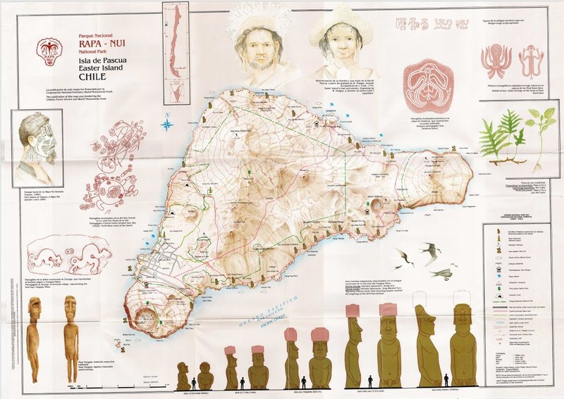
The Rapa Nui map below is an example of a Poor map: it was clearly made for different purposes (a tourist brochure?) and the legend does not tell us what the boundaries of the core zone are (probably the national park boundaries, but these are confusing).
Notable findings
Many WHS locations received small updates, but two general findings stood out during this stage:
Underground components: some 7 WHS have components that are underground only; we have them gathered in a connection already. These should be displayed visually differently on the maps.
Country maps specifics
In addition to the Site Pages, where they are of the most use, the core zones are also displayed on the maps on the Country Pages. I am not completely sold on that yet - yes, it can be good to show parks covering large areas, but in general, it just adds more complexity to the already cluttered picture of countries with many (T)WHS.
And there are some specific issues with core zones on country maps:
- At Transboundary WHS, the core zone will "spill" into the neighbouring country. This does not bother me really, it may be interesting to know that the zone goes on beyond the border.
- With Serial Transnational WHS, the core zones are scattered across multiple countries, which takes the focus away from the single Country Map. Here, for now, we will apply the workaround to split them into separate files per country.
- Boundary sensitivity issues. These come twofold: on the one hand, sometimes, while drawing, a zone accidentally goes beyond a border for a bit (and then it will show up on the other country's map as well). These user mistakes should be adjusted manually. On the other hand, the underlying master map has some difficulties as well: it finds it hard to register that Surtsey is part of Iceland, for example, or that Sarazm is in Tajikistan and not in Uzbekistan. It doesn't lead to major issues as long as we still have the right dots, but it seems sloppy.
If you want to start mapping as well, read this F.A.Q. first. Also, I am interested in hearing your opinion about displaying the core zones on the country maps: does it add value?
Comments
4 comments