Blog TWHS Visits
Guayabo National Monument
Costa Rica’s Tentative List has only one entry, so for the second time I will review one of its FTWHS as they are the country’s best cultural sites. The Guayabo National Monument is its most important archaeological park. It comprises a settlement created by one of the local pre-Columbian chiefdoms; it flourished between 1000 - 1400 AD. Guayabo has been designated as International Historic Civil Engineering Landmark for its extensive roadways and water supply system.
I arrived by car from the north, from San José via road #230. It’s only 80km but it will take easily 2 hours because of the winding roads and pedestrians/cyclists on the road. The Guayabo National Monument is well signposted almost directly after you leave San José. 95% of the route is covered by an excellent asphalt road, but at the end there is an unpaved stretch of five kilometers. It’s not too bad, but I was happy that I rented a car with high clearance. On the way out by the way I took the southern loop (via route #415) and that one is fully paved.
Guayabo is quite a popular attraction with the locals, of which several dozens showed up on the Sunday that I visited. Payment at the entrance is by credit card only (5 USD for foreigners). The site is located in a nice patch of rainforest and I enjoyed being in the tropical nature again.
On the way to the partly excavated ruins of the settlement you’ll encounter water works and a stone with petroglyphs. The stone is carved on both sides, with an image of a lizard on one side and that of a jaguar on the other. The water network had open and closed aqueducts, canals and storage tanks. Some of these waterways are still functioning and provide clean spring water. In the central area you can see that the water flows into ponds near the residences.
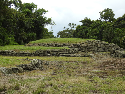
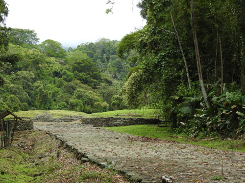
The ruins lie in a large clearing in the forest. The city here is said to have had 2,000 inhabitants (a number of 10,000 is also often mentioned but that seems like a lot, it may relate to the wider area). The people lived in large communal wooden houses with thatched roofs. These stood on circular stone plateaus, and that is all that is left. The trail takes you along a number of those plateaus. It ends at another strong piece of infrastructural architecture: a long and wide stone road that enters the city. The best view of it all can be had from the Mirador that overlooks the site - there you see how the road runs straight into the city. At its start lie two square plateaus, which may have been watchtowers for the defense of the city. The city is further enclosed by a dense rainforest.
After walking the same part of the route for the third time, I turned to the exit. That way I found out that the central excavation area actually is very close to the ticket office, there is a 400m long trail for the disabled that takes you directly to the ruins. With my longer loop though I spent an hour and a half on site.
Guayabo was rejected from becoming a WHS in 1984 - citing "its current state" and offering the option to renominate when further excavations "produce results of exceptional universal interest". Although it’s no rival to Machu Picchu or the Mexican archaeological sites, it’s not bad either and can match for example the Qhapaq Nan serial sites such as Ingapirca. I especially enjoyed the ingeniously constructed water network and the old road.
Els - 24 March 2021
Comments
Esteban Cervantes Jiménez 29 March 2021
Well, it's great to see that you enjoyed it. Yes, the best way is to go to the lookout point first and then down to the archaeological site. Plus, Turrialba is rich in other cultural things of interest, like the coffee-town of Aquiares (my favorite in the country), railroad history in Turrialba and Peralta, cheese-production in Santa Cruz, churches like the one in La Pastora, Aquiares or San Antonio, etc. On the other hand, I see no interest from the government to even update the country's TList, so I have the impression that its pretty improbable (for the moment), the country will ever put this site forward again.


