Cuetzalan and its Historical, Cultural and Natural Surrounding

Cuetzalan and its Historical, Cultural and Natural Surrounding is part of the Tentative list of Mexico in order to qualify for inclusion in the World Heritage List.
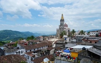
Cuetzalan is a town located in the Sierra Norte mountains. It is characterised by steep cobblestone streets and an architecture that reflects indigenous traditions and living in the mountains. The natural environment around the town includes extensive forests, numerous waterfalls and caverns.
Map of Cuetzalan and its Historical, Cultural and Natural Surrounding
Load mapThe coordinates shown for all tentative sites were produced as a community effort. They are not official and may change on inscription.
Community Reviews
Jarek Pokrzywnicki

Cuetzalan or Cuetzalan del Progreso – site visited in February, 2024.
On a map it looks as nice stopover while travelling from Mexico City to El Tajin. It is a bit more than 300 km from MEX airport but since the roads are not perfect and you drive partly through the mountains it took around 8 hours to get there (instead of 5 - 6 as shown in navigation). In fact it was one of the worst road I have encountered in Mexico (so many holes in asphalted roads, speed bumps while driving through populated areas – some of them require speed of 10 km/h and they not always marked). All in all not recommended to get there in the night.
Cuetzalan is a small town located in mountainous region of Sierra Norte. It was proclaimed Pueblo Magico (Magical Town) in 2002 - Mexican idea to promote small historical and heritage towns including those already on UNESCO list like Tequila, Tepotzotlán (Camino Real), Tepoztlán (Popocatepetl monasteries), Jalpan de Serra (monasteries of Sierra Gorda) or Pabellón de Hidalgo (Camino Real). And Cuetzalan is no exception. Historic center is quite picturesque full of cobbled streets and old stone houses covered with red tiles. Daily life is focussed on market square (Zocalo) where municipality buildings are located and numerous trading posts with local craft, souvenirs and food. There is also a big church (Parroquia de San Francisco de Asís, interior is visibly of XIX century) and a huge pole for ancient ritual flying (voladores) - Danza de los Voladores, or Dance of the Flyers, was recognised as an Intangible Cultural Heritage by UNESCO. You may see that also on a square just before the entrance to El Tajin museum.
The whole city looks quite touristic with lots of restaurants, cafeterias, different hotels. For me it is quite similar to Salamina (Zona Cafetera, Colombia) but it may be just my imagination based on similarities in landform and street layout. Outside the city there are different scenic spots like caves or waterfalls (Cueva de Arena, Grutas Apipias), further north there are Pre-Columbian ruins of Yohualichan.
More about Cuetzalan and surrounding area https://www.visitpuebla.mx/en/magical-towns/cuetzalan-en
Practicalities: For transportation I used a rented car but there is also public transport there (at least ADO bus company has its terminal there), stayed in Posada Quetzalin (google coordinates N 020° 0.944, W 97° 31.551) – good budget place (23 USD for double without breakfast) – nice panoramas of the town from viewing platform.
Places on the photo, bottom left, than clockwise: Zocalo with local trade, typical street in the Old Town, on a local market, mural
Site Info
- Full Name
- Cuetzalan and its Historical, Cultural and Natural Surrounding
- Country
- Mexico
- Added
- 2006
- Type
- Mixed
- Categories
- Natural landscape - Forest Urban landscape - Latin American
- Link
- By ID
Site History
2006 Added to Tentative List
Site Links
Locations
The site has 1 locations
Visitors
8 Community Members have visited.