Dababiya

Dababiya is part of the Tentative list of Egypt in order to qualify for inclusion in the World Heritage List.
The Dababiya Quarry Beds are a geological site that show the Paleocene/Eocene Boundary. They are the official reference base for the Ypresian, the oldest age of the Eocene.
Map of Dababiya
Load mapThe coordinates shown for all tentative sites were produced as a community effort. They are not official and may change on inscription.
Community Reviews
Philipp Peterer

The suggested OUV of Dababiya is that it is a one of the Global Standard-stratotype Sections and Points (GSSP). It’s a place where the boundary between the Paleocene and the Eocene is clearly visible. This makes it a rather geeky Paleontological site to visit, but still interesting and not less valuable. To make it a bit more reliable for other visitors, it was also used as a quarry for the buildings of nearby Luxor/Karnak temples.
The site is around 1h drive south of Luxor, along the scenic Nile route. You pass by when you do the Luxor-Aswan drive to visit the Esna/Elfu/Kom Ombo temples. Get off the Luxor-Aswan Eastern Desert Road in Ash Shaghab (crossing the only bridge over the canal) and follow the signs. It’s mostly narrow dirt roads that lead through the village and outside to the main entrance.
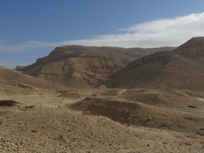
We arrived there at 16:15, but found the gate closed. While discussing what to do now, an employee with his tractor approached us from inside. He didn’t speak much English but was probably the nicest Egyptian in the country and after a call with his boss let us in. We drove up to the visitor center, where he got us some brochures and then to the actual site. There is not much more to see than what is on the picture, but still nice and worth the visit.
Site Info
- Full Name
- Dababiya
- Country
- Egypt
- Added
- 2008
- Type
- Natural
- Categories
- Paleontology - Non-hominid fossils
- Link
- By ID