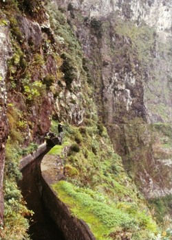
Levadas of Madeira Island

Levadas of Madeira Island is part of the Tentative list of Portugal in order to qualify for inclusion in the World Heritage List.
The Levadas of Madeira Island are a system of canals and aqueducts built to transport water from the mountains with high rainfall in the centre of the island to the agricultural areas on the coast. The first levadas were built as early as the 15th century, just a few years after the island was settled. The property includes the primary public and private waterways with year-round water flow, which have a total length of about 800 kilometres.
Map of Levadas of Madeira Island
Load mapThe coordinates shown for all tentative sites were produced as a community effort. They are not official and may change on inscription.
Community Reviews
Matejicek

I explored many long kilometers of Levadas during my week trip to Madeaira in January 2012. We crossed the island by walk, and naturally, these canals, designed for efficient water management of the island, were more than often only possibilities how to commute in the rocky landscape of Madeira. I have strong memories especially to 1 or even 2 km long tunnels, where your own light is a necessity, and the stream of water in Levadas is so rapid but very silent there. I think that this water management system would deserve WHS status much more that the canals in Augsburg.
The net of Levedas is quite dense and but they are diverse (I liked Levada da Janela, Levada das 25 Fontes, Levada do Risco, Levada do Paul, Levadas to the Souths from Sao Vincento, and Levadas around Ribeiro Frio, etc.). Most of them are still in use, but we saw also some parts without water. However, even dry Levadas are very useful for walking in otherwise impenetrable landscape. In the relatively small parts of central plateau, we also walked along untypical types of Levadas that are not such dramatic but still beautiful, as shown in PHOTO (parts of Levada do Paul).
Walter

The levadas of Madeira island are a system of channels and aqueducs collecting waters from the mountains and bringing them down to the coastal areas, for irrigation of lands or hydroelectric plants.
Levadas are widespread around the island. They pass through forests (notably the Laurisilva Forest on the WHL), going hillside, hanging on almost vertical cliffs or going through tunnels. Building them was an engineering achievment, Madeirans are very proud of. This project can be compared with the “Aflaj Irrigation Systems of Oman”. For me, it clearly has an OUV.
Many hiking trails follow the course of the levadas. A practical guide is published by Rother Wanderfuhrer, available in German , English and French (rother.de).
A presentation of this project, in portuguese but with some nice picture is avaiblable on the following link : (http://www.ppa.pt/wp-content/uploads/2016/03/1.-Miguel-Sequeira.pdf)
I visited Madeira a few years ago. Walking along the levadas is one of the most rewarding experience on this island. Choose carefully the levada you going to visit, especially if you fear heights, as some are litterally hanging on cliffs, and you get to walk on a 50 cm large stone wall above the abyss without any guardrails.
I recommend the upper part of the Levada do Norte, as one of the most impressive levada (but be extremely careful however, as a british women died after falling from the trail in november 2016), or the Ribeira de Janela, going in a valley deep in the Laurisliva WHS forest. A quieter levada (also in the Laurisilva WHS) would be Levada do Furado.
Getting to trailhead is easier with a rental car, but can also be reached by public transport.
Community Likes
Site Info
- Full Name
- Levadas of Madeira Island
- Country
- Portugal
- Added
- 2017
- Nominated for
- 2027
- Type
- Cultural
- Categories
- Structure - Civic and Public Works
- Link
- By ID
Site History
2024 Requested by State Party to not be examined
After a Not to inscribe advice by ICOMOS
2017 Added to Tentative List
Site Links
Visitors
70 Community Members have visited.