Nasca Aqueducts

Nasca Aqueducts is part of the Tentative list of Peru in order to qualify for inclusion in the World Heritage List.
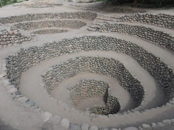
Nasca Aqueducts is a network of underground aqueducts built by the Nazca people to carry and use the intermittent water sources of the Andes in the dry desert of the region. This was made possible by the development of several technical innovations, including reservoirs, a filtration system, and above all helical openings to equalise the pressure between the inside and outside of the pipe and thus ensure a constant flow in the pipe. This hydraulic system was built in one of the driest deserts on the planet and represents an exceptional adaptation to these difficult conditions, allowing at the same time the colonisation of these territories and the practice of agriculture.
Map of Nasca Aqueducts
Load mapThe coordinates shown for all tentative sites were produced as a community effort. They are not official and may change on inscription.
Community Reviews
Dennis Nicklaus

The Nasca Aqueducts are a very impressive work of hydrological engineering from the pre-Columbian Nazca culture. The Cantalloc Aqueducts are the best preserved of these, just outside the city of Nazca. The Nazca culture flourished between about 200 and 700 A.D., and these aqueducts are generally dated to around 300 A.D. Several of them still have water flowing through them and are useful today. A large part of the extensive network of water channels (many kilometers) is/was underground, which makes the work even more impressive to me, that the ancient Nazca were able to build and maintain these. At Cantalloc, the most visually striking element are the broad spiral access points. These stone-lined spiral wells provided ventilation needed to keep the water flowing as well as access points for water collection. I was told there were 14 of the spirals at the Cantalloc site remaining, although access to some of them was restricted during my visit. Not a big deal as they are mostly all the same.
The OUV of this site was apparent to me, demonstrating the ingenuity of this ancient culture to master the handling of precious water in the desert.
What you'll see at the site
We started off at the open irrigation channel that's at the end of the aqueducts. It's a nice stone lined ditch with some shade trees, nothing special on its own. Then, as you walk upstream, you come across the spiral access points. There are several in a row, then the split into a Y, with the two arms having more spirals along them. Each spiral is maybe roughly 10 meters in diameter, and about 2-3 meters deep. You can walk down into them (along the spiral path), and touch the water of the underground aqueduct flowing below.
While you're in the area
Of course, the Nazca lines are the most famous draw. But besides them, I also very much enjoyed my visit to the Cahuachi Pyramids, about a half hour drive out of Nazca city. Cahuachi was an ancient ceremonial/religious center for the broad Nazca culture. The grand adobe buildings there are still being actively investigated. I could see a broader inscriptions for sites of the Nazca culture including the aqueducts and the pyramids. But I think these aqueducts are unique enough to stand on their own, also.
From the Cantalloc Aqueducts site, you can see a very impressive cat figure etched onto a nearby mountainside (see photo), thought to be from the Paracas culture from its style. The Paracas culture came before the Nazca.
Nan

Part of the appeal of the Nasca Lines, is the fact that they seem so out of place. Clearly, the people who created them had knowledge and skill. But why would they settle in the middle of the desert in the first place? From the bus window all I saw was sand. The Nasca Aqueducts help to explain a little how they survived here: They set up an elaborate water management system enabling to conduct agriculture.
As usual with tentative sites it's pretty hard to say what the final scope of the inscription will be. I would assume the Cantalloc Aqueducts in town are part of the site, but who knows?
OUV
As stated year's back in my original review, I feel this should be part of the Nasca WHS itself. As an extension to illuminate the Nasca culture more I would be fully in favour of including some settlements as well as water management sites. As a separate site, though, this would feel redundant.
Getting There
It's a simple walk from the town center to the Cantalloc Aqueduct. However, Lonely Planet claimed the neighbourhood was dangerous. Not sure about that. From the aqueduct you can also reach the lines at Telar and the old settlement at Los Paredones.
Nasca itself is connected by bus to both Lima and Arequipa (more details in my Nasca review). Next major town is Ica.
While You Are There
Obviously, if have made it to Nasca, you came to see the Nasca Lines. Around Pisco and Ica are the Pisco sites (T). On the coast you find plenty of Guano Islands (T), most famously the Islas Ballestas. And there seem to be some Paleontological Sites (T).
Community Likes
Site Info
- Full Name
- Nasca Aqueducts
- Country
- Peru
- Added
- 2019
- Type
- Cultural
- Categories
- Structure - Civic and Public Works
- Link
- By ID
Site History
2019 Added to Tentative List
Site Links
Visitors
28 Community Members have visited.