Bassari Country
Bassari Country: Bassari, Fula and Bedik Cultural Landscapes represent an isolated, multicultural society of communities who practice traditional agriculture.
A mix of Bassari, Fula and Bedik peoples live in agricultural villages that were settled by several waves of migrations from the 11th-13th century on. The villages are located in a hilly, difficult-to-access landscape.
Community Perspective: the villages are hard to reach, but Stanislaw visited three of them in Bedik Bandafassi. Els went to Andiél in the same area and checked out the Dindefello waterfall.

Map of Bassari Country
Community Reviews
Els Slots

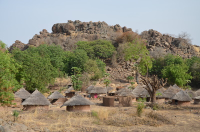
Bassari Country is almost contiguous with that other East Senegal WHS, Niokolo Koba National Park. However, you must drive around the park (2.5-3 hours) to get to where the Bassari live. Along the way, you will already see plenty of traditional houses in mixed villages by the roadside.
We started our visit at location #3, Dindefello. This is a typical mixed village on lower ground, inhabited mostly by Fula and with ‘modern’ houses as well. It has a fine setting with the massive wall of the Fouta Djalon Massif rising behind it. On its main street, there’s a Visitor’s Center where you have to pick up a local guide and pay for access to the waterfall.
Dindefello Falls are the region’s pride but it is hard to imagine a sizeable waterfall in this dry landscape. We had to walk for half an hour through the forest to get there. The path is adjacent to a river, where women cleaned their laundry by ‘beating’ it on stones. The noise sounds like gunshots. The waterfall was no disappointment: a long, sheer drop coming from the rocks. A pool had formed below it; my guide and driver tried it, but the water was too cold in the early morning for a swim.
The guide had promised me a visit to a ‘real real’ village as well. After some deliberations with the guys at Dindefello reception, we were given a contact number for a local guide who could give us access to Andiél. This is a Bedik village, part of WHS location #2, Bedik Bandafassi. It required a 20-minute drive. The guide was already waiting by the roadside and he directed us to the town. We had to pass a large army compound and then parked our car under a tree near a farm.
From there we had to walk – but to where? A steep rock wall was looming but no village could be seen from the ground. Upon closer look, there was sort of a natural flight of stairs against the rocks. Climbing this, we reached the village in 20 minutes. The forefathers of the Bedik had chosen this hidden location to preserve their traditions and not be assimilated into the Islamist culture of the Fula. The Bedik still are mostly animist, although this village has a Catholic church as well (a round reed hut like all the others, but with a cross on the roof). The biggest difference with the roadside villages is that the huts in the mountain villages are built much more closely together – an extra layer of defense.
We started our visit by shaking hands with a few village notables and the village chief, who wasn't doing well (it looked like he had suffered a stroke). Some money was paid (I believe we paid the chief and the local guide 5000 XOF each) and then we could look around the village freely. The local women in the meantime had set up a display of souvenirs for sale, mostly bracelets made of beads. Children were following us all around.
Andiél is the first village on this ridge - if you walk on, you will encounter even more isolated Bedik villages. It has 235 inhabitants. The Catholic missionaries had built a pharmacy and a school, but at least the latter has now fallen into disrepair. If I understood well (the local guide and I communicated in broken French, even my Gambian guide with Wolof, Mandinka and Fula on offer could not find a common language with him), the children go to school now at the army base at the bottom of the hill. One of the biggest dangers nowadays of living in this village is wildfires - a stretch around the village is deliberately burnt down to prevent fires from encroaching.
Read more from Els Slots here.
Stanislaw Warwas

Visited February 2017.
It is not easy to get there – west of Kedougou there are no roads and I can hardly imagine how they travel in the rainy season…
This inscription contains three parts: Bassari (Salemata village as a starting point), Bedik (Bandafassi) and Fula (Dindefelo). The closest to the city of Kedougou is Bedik Bandafassi which in my opinion is the most interesting – some small villages on the top of the mountains, with only 3000 people living there. It’s good to visit at least three, four of them but you need one day of very intensive walking and a guide because they are not easy to find. It is not a tourist trap and the Bedik people are very friendly. Just give some money to the chief of the village and walk freely, take as much pictures as you want. Bedik speak their own language, belonging to Niger-Congo family and has some similarities with some Tenda group languages. Their religion is a blend of animist and Christianity, and their most important village – Iwol. The Bedik came here possibly in the 18th / 19th centuries from Mali, and most of them bear Keita as their family name. Most of their original villages are deserted now because of the lack of water.
Dindefelo is less interesting and I think half day moto trip from Bandafassi is enough to see the most representative villages and the waterfall, the biggest one in this part of Africa – but it is nothing special. The Fula people can be seen everywhere in Sahel; they are traders so when you get to Dindefelo, be ready to meet many of them willing to sell you overpriced “traditional” masks or sculptures…
Bassari country with Salemata as a starting point is commercialized as no other place in Senegal. It is strange because no many tourist coming here. Here you have to pay for everything: visiting villages, taking pictures, local guides, local chiefs… If you can pay 50 Euros they can arrahne a traditional ceremony just for you! It is located around 80 km from Kedougou but it takes around 3 hours to get there using the sept-places old Peugeot; and there is only one vehicle a day, except Thursday, market day. I was a bit disappointed and tired after a day there… Of course, the local architecture and traditions are very interesting. Be sure that you do not miss your transport back to Kedougou! If you want to hire somebody from the village you’ll have to pay something like 80 euros!!!
Site Info
- Full Name
- Bassari Country: Bassari, Fula and Bedik Cultural Landscapes
- Unesco ID
- 1407
- Country
- Senegal
- Inscribed
- 2012
- Type
- Cultural
- Criteria
-
3 5 6
- Categories
- Cultural Landscape - Associative
- Link
- By ID
Site History
2012 Advisory Body overruled
Referral was suggested by ICOMOS
2012 Inscribed
Site Links
Unesco Website
Connections
The site has 16 connections
Art and Architecture
Geography
History
Human Activity
Religion and Belief
Timeline
Trivia
Visiting conditions
Visitors
14 Community Members have visited.
The Plaque
No plaque has been identified yet for this site.